Editor Picks
latest posts
From neon-hued city streets to breathtaking natural phenomena, some nations truly celebrate a full spectrum of vivid palettes.
India: India is a brilliant explosion of colour deeply rooted in its culture. From women’s stunning, bright saris to bustling spice markets, every corner feels completely alive. Cities like Jaipur are painted entirely pink, while the legendary spring festival of Holi blankets the entire nation in a joyful, swirling cloud of technicolor powders.
Mexico: Mexico absolutely loves bold and bright self-expression. In the hillside city of Guanajuato, houses resemble a stacked grid of mismatched pastel blocks, while the pink lakes of Las Coloradas dazzle the eyes. Every street feels like a festival, decorated heavily with vibrant papel picado flags and blooming bougainvillea.
Morocco: Morocco feels like stepping right into a historic storybook rich with earthy tones and striking accents. The markets are packed with golden spices, but the crown jewel is Chefchaouen. Tucked into the mountains, this entire dreamlike town features winding alleys, doors, and stairs painted in captivating, endless shades of blue.
Colombia: Colombia beautifully blends rich natural wonders with human artistry. The village of Guatapé stands out because every home features bright paint and detailed, colorful illustrations carved into the walls. Deep in the jungle, the magnificent Caño Cristales river turns brilliant shades of red, yellow, and green from aquatic plants.
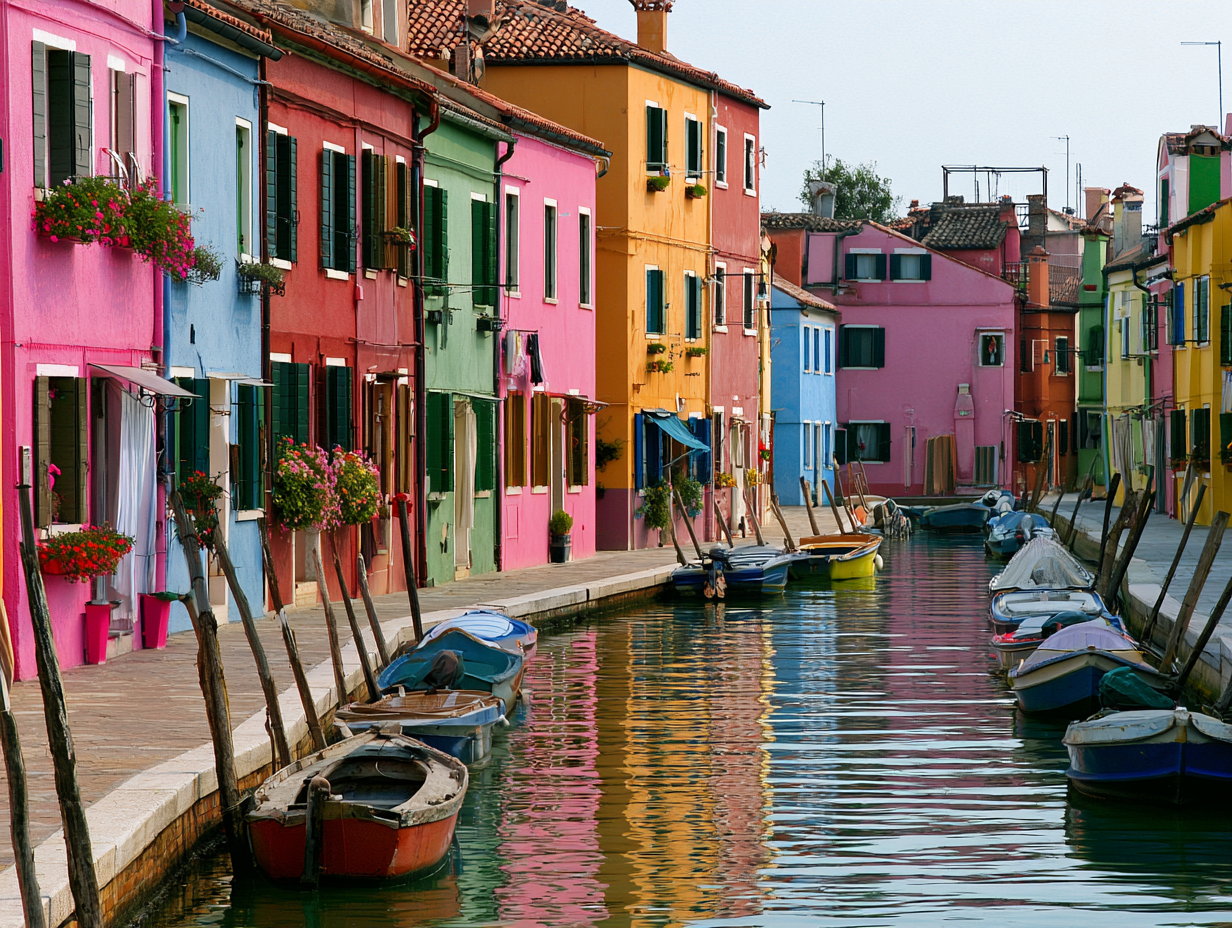
Italy: Italy proves that European history can be incredibly vibrant. The northern island of Burano features rows of fishermen’s houses painted in neon pinks, greens, and yellows to cut through the lagoon mist. Meanwhile, the famous seaside cliffs of Cinque Terre boast cascading clusters of pastel buildings overlooking deep turquoise waters.
South Africa: South Africa offers spectacular visual diversity, most famously displayed in Cape Town’s iconic Bo-Kaap neighborhood. Here, the historic cobblestone streets are lined with houses painted in brilliant shades of fuchsia, lime green, and bright orange. This radiant display beautifully reflects the joy, resilience, and multi-cultural identity of its residents.
Cuba: Cuba feels beautifully frozen in a bygone era, defined by the striking pastel facades of Old Havana. The historic streets are famously filled with meticulously maintained 1950s American classic cars painted in candy-apple red, turquoise, and canary yellow, creating a nostalgic, moving masterpiece against the tropical Caribbean sun.
Japan: Japan expertly balances soft, minimalist tones with jaw-dropping bursts of seasonal color. In spring, the entire country is blanketed in soft pink cherry blossoms, which sharply transitions into the neon glow of Tokyo’s nighttime streets. Massive flower parks like Hitachi Seaside Park feature rolling hills covered in ocean-blue nemophilas.
Netherlands: The Netherlands transforms every spring into a sprawling, multi-colored canvas that can be seen from the sky. Millions of meticulously planted tulips bloom simultaneously across the vast countryside, creating massive, perfectly straight ribbons of deep red, bright yellow, and royal purple that stretch out as far as the eye can see.
Peru: Peru’s colors are deeply woven into its striking landscapes and rich indigenous textiles. The breathtaking Rainbow Mountain features natural, mineral-rich stripes of turquoise, lavender, and gold carved into the Andes. Down in the valleys, locals spin and wear beautifully intricate traditional garments dyed with vibrant, locally sourced plant extracts.
A whirlpool is a rotating body of water formed when two opposing currents meet, when a strong tidal race squeezes through a narrow strait, or when fast-flowing water passes over an irregular seabed. Small whirlpools form at the base of waterfalls and at dams and weirs. The most powerful ones, called maelstroms, occur in straits, narrows, and tidal channels where the periodic exchange of large volumes of seawater is constrained by geography.
How Is The “Size” Of A Whirlpool Even Measured?
There is no single standard measurement for whirlpool size. The two metrics most commonly used by scientists and mariners produce different rankings, and most popular lists silently mix them. The first is maximum current speed, the velocity of the tidal flow through the strait, recorded in knots or kilometers per hour. This is what most authoritative sources use when they call a whirlpool “the strongest” or “the largest” because current speed is consistently measurable and closely tracks the kinetic energy and power of the vortex. The second is maximum visible vortex diameter, the width of the rotating surface depression at the peak of tidal flow. Vortex diameter is more intuitive but less rigorous: the visible whirlpool changes width continuously through each tidal cycle, varies with weather, and at some sites is not a single fixed feature at all but a wandering set of vortices.
By max current speed, Saltstraumen in Norway is the most powerful tidal whirlpool in the world. By max diameter, Old Sow off the coast of New Brunswick is larger. The ranking below is ordered by maximum tidal current speed, the more rigorous metric. The table at the end shows both measurements for each whirlpool so readers can see how the order changes.
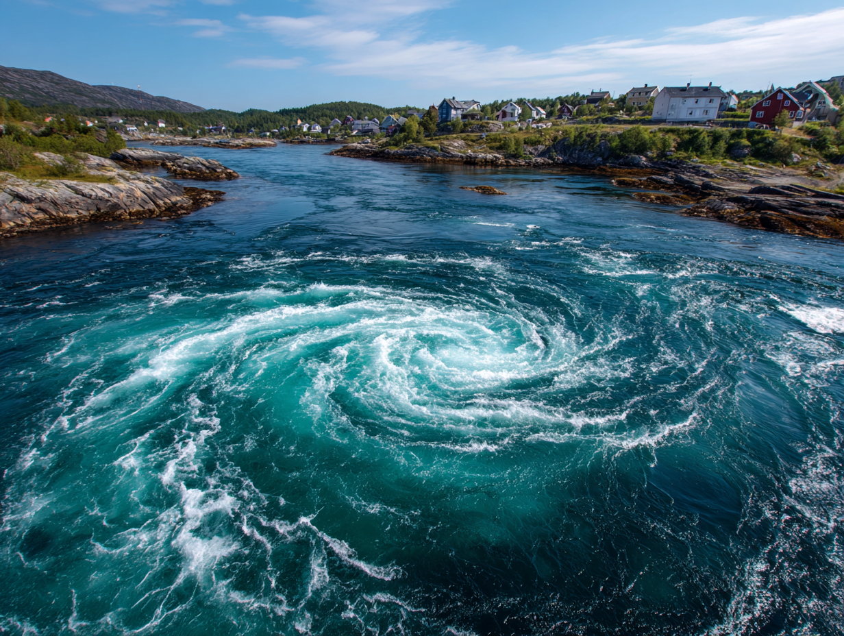
1. Saltstraumen (Norway)
Saltstraumen is a narrow strait in northern Norway about 33 kilometers southeast of the city of Bodø, in Nordland County, and is recognized as the strongest tidal current in the world. Its maximum current speed reaches 22 knots (40 km/h or 25 mph), faster than any other tidal current that has been reliably measured. Every six hours the strait carries an estimated 400 million cubic meters of water between the Saltfjord and the larger Skjerstadfjord, a volume equivalent to 105 billion US gallons, through a channel only 3 kilometers long and 150 meters wide. The whirlpools that form when the current is at its peak reach about 10 meters (33 feet) in diameter and 5 meters (16 feet) in depth. The strait is also one of the richest fishing grounds in Norway: cod, wolffish, and saithe are caught here in large numbers, including the world record saithe at over 22 kilograms.
2. Moskstraumen (Norway)
Moskstraumen is the second-fastest measured tidal current in the world, with peak speeds of about 27.8 km/h (17.3 mph or 15 knots). It is also the largest individual whirlpool by surface diameter on this list: its central vortex measures 40 to 50 meters (130 to 160 feet) across at peak flow. It forms in the open Norwegian Sea between the islands of Moskenes and Værøy in the Lofoten archipelago of northern Norway, where strong Atlantic tides meet the deep Vestfjorden over a sharply uneven seabed. Unlike most whirlpools, which form in confined straits, Moskstraumen forms in open water. It is the original “Maelstrom”: the English word derives from the Dutch “maalstroom” and the Norwegian “Moskenstraumen.” The whirlpool was labeled “Horrenda Caribdis” on Olaus Magnus’s 1539 Carta Marina, inspired Edgar Allan Poe’s 1841 short story “A Descent into the Maelström,” is referenced in Jules Verne’s “Twenty Thousand Leagues Under the Sea” and in Captain Ahab’s dialogue in Melville’s “Moby-Dick.”
3. Old Sow (Canada-United States border)
Old Sow sits in Passamaquoddy Bay between Deer Island in New Brunswick, Canada and Moose Island in Eastport, Maine. It is the largest whirlpool in the Western Hemisphere by surface diameter, reaching up to 76 meters (250 feet) across at peak flow, and one of the strongest tidal currents in the world, recorded at peak speeds of about 27.6 km/h (17.1 mph), just behind Moskstraumen. The whirlpool forms during the extreme tidal exchanges between the Bay of Fundy (which has the largest tidal range in the world) and Passamaquoddy Bay, accelerated by the unusual seafloor topography in the area. The name comes from the pig-like noises the churning water produces; smaller surrounding eddies that swirl alongside the main vortex are nicknamed the “piglets.” The best viewpoint is Deer Point on Deer Island or the Eastport waterfront on Moose Island.
4. Skookumchuck Narrows (British Columbia, Canada)
Skookumchuck Narrows forms the entrance to Sechelt Inlet on the Sunshine Coast in British Columbia, about 60 kilometers north of Vancouver. The tidal flow through the strait and the combined flows of Salmon Inlet and Narrows Inlet meet at the Sechelt Rapids, where peak current speeds have been recorded at over 30 km/h (about 16 knots or 19 mph), making this among the fastest tidal rapids in the world by some measurements. The water level difference on either side of the rapid can exceed 2 meters (6.6 feet). Skookumchuck is more accurately described as a tidal race that produces whirlpools rather than a single discrete whirlpool, which is why some authoritative rankings exclude it from the standard “fastest whirlpool” list even though its current speeds are substantial. The rapids are reached by a 4-kilometer hike to Roland Point or North Point and are popular with extreme kayakers and divers.
5. Naruto Whirlpools (Japan)
The Naruto whirlpools form in the Naruto Strait, the 1.3-kilometer-wide channel between Naruto in Tokushima Prefecture and Awaji Island in Hyōgo Prefecture, one of the connections between Japan’s Inland Sea and the Pacific Ocean. The tidal range in the strait reaches up to 1.7 meters, creating a difference in water level between the two sides of up to 1.5 meters. The resulting current flows through the strait at about 13-15 km/h normally, accelerating to 20 km/h (about 11 knots) during spring tide, the world’s fourth-fastest measured tidal current after Saltstraumen, Moskstraumen, and Old Sow. The whirlpools formed at peak flow can reach 20 meters (66 feet) in diameter. The best viewing point is the Uzunomichi Walkway on the 1985 Ōnaruto Bridge or from the Awaji-side shore. The whirlpools also gave their name to narutomaki, the steamed surimi fish cake with its distinctive pink spiral.
6. Corryvreckan (Scotland)
The Gulf of Corryvreckan is a narrow strait between the islands of Jura and Scarba in the Inner Hebrides off the west coast of Scotland. The Gaelic name, “Coire Bhreacain,” means “cauldron of the speckled seas.” On a full spring tide, the current through the gulf reaches 8.5 knots (16 km/h or 10 mph), slower than the other entries on this list, but unusual seabed geometry produces a particularly violent whirlpool: a 219-meter-deep hole on the eastern end is followed by a sharp rise to a basalt pinnacle (called the Old Hag) that comes within 29 meters of the surface, forcing water upward in pulses that dissipate into vortices and standing waves up to 9 meters tall. Corryvreckan has been described in older guidebooks as the world’s third largest whirlpool, a claim that almost certainly refers to its violence rather than current speed. The roar can be heard 10 miles away. George Orwell, writing “Nineteen Eighty-Four” on Jura in 1947, nearly drowned in Corryvreckan that August when his boat got caught in the whirlpool with his young son aboard.
Notable Mention: Te Aumiti (French Pass), New Zealand
Te Aumiti, also known as French Pass, is the narrow strait separating D’Urville Island from the South Island of New Zealand at the northern tip of the Marlborough Sounds. Tidal flows through the pass reach approximately 8 knots (about 15 km/h), comparable to Corryvreckan, with whirlpools and standing waves. The pass was named for French explorer Dumont d’Urville’s 1827 transit, considered one of the most dangerous attempted crossings of the era. It is not typically included in global top-five whirlpool rankings but is the most significant tidal whirlpool in the Southern Hemisphere.
Forests are among the planet’s most important ecosystems. They store carbon, shelter much of the world’s wildlife, regulate the water cycle, and provide food, fuel, and income for billions of people. The UN Food and Agriculture Organization (FAO) defines a forest as land covering at least half a hectare, with trees taller than five metres and a canopy shading more than ten percent of the ground. Land used for crops or built up into towns and cities does not count, even where tall plants grow on it.
By that definition, forests cover about 4.06 billion hectares, or roughly 31 percent of the world’s land, according to the FAO’s most recent global assessment. About 1.1 billion hectares of that, more than a quarter of the total, is primary forest that is largely undisturbed and dominated by native species. The cover is not spread evenly. Europe, including the vast woodlands of Russia, holds about a quarter of the world’s forest, more than any other region, while Oceania holds only about five percent. Asia carries the smallest share of any region except Oceania, even though it is by far the largest continent.
Just ten countries hold about two-thirds of the world’s forest, and more than half of it sits in only five: Russia, Brazil, Canada, the United States, and China. Russia alone accounts for roughly a fifth of the global total, and forest still covers about half of its enormous territory. At the other end of the scale, more than 90 percent of Suriname is forested, the highest share of any country. Dozens of nations sit far below that. More than a dozen have forest on less than one percent of their land, and around thirty have five percent or less. The countries with the least tree cover fall into a few clear patterns, set mostly by climate and crowding.
Small, Crowded Countries Run Out Of Room For Trees
In a handful of very small and very crowded countries, there is simply little land left for forest. Monaco, the most densely populated country on Earth, packs tens of thousands of people into about two square kilometres and has no forest at all. The Pacific island of Nauru, just 21 square kilometres, is in the same position. Two other island nations do only a little better: Kiribati and the Maldives each keep a sliver of forest, somewhere between one and three percent of their land. At this size, housing, roads, and farmland leave almost nothing for trees.
The Arid Heart Of Western And Central Asia
Asia holds only about 15 percent of the world’s forest, the smallest share of any inhabited continent apart from Oceania, even though it is the largest landmass on Earth. Much of it is dry. Some of the least forested countries anywhere lie in Western Asia, on and around the Arabian Peninsula. Qatar, Oman, and Kuwait have effectively no forest, while Saudi Arabia and Yemen sit at about one percent or less. The United Arab Emirates, at roughly five percent, is the greenest country on the peninsula. The cause is the Arabian Desert, which covers some 2.3 million square kilometres. It is the largest desert in Asia and the fourth largest in the world, and its heat gives trees almost no chance.
Central Asia tells a similar story. Forest covers under ten percent of Turkmenistan and Uzbekistan (each around eight to nine percent), Kyrgyzstan (about seven percent), Tajikistan (three percent), and Kazakhstan (barely one percent), and the numbers are just as low in Afghanistan (two percent) and Pakistan (under five percent) to the south. Two great deserts dominate the region: the Karakum, which covers roughly 70 percent of Turkmenistan, and the Kyzylkum, which spreads across Uzbekistan and Kazakhstan.
The Sahara Dominates North Africa
Africa’s forests cover about 637 million hectares, roughly a fifth of the continent’s land. The Sahara explains much of the shortfall. It is the world’s largest hot desert and the third largest desert of any kind, behind only the Antarctic and Arctic, and it sweeps across the whole of North Africa over some 9.2 million square kilometres. Egypt, Libya, Mauritania, Algeria, Niger, Chad, and Tunisia all sit within or along it, and each has tree cover of five percent or less. With almost no rain and punishing heat, forests cannot take hold.
South of the Sahara lies the Sahel, a semi-arid belt about three million square kilometres wide. Its countries are greener than the desert states to the north, but several still rank among Africa’s least forested, including Mali, Sudan, South Sudan, and Eritrea. Tree cover then rises steadily as the dry land gives way to wetter savanna and tropical forest further south.
The Dry Corners Of Southern Africa
Forest is scarce in the driest parts of southern Africa as well. Namibia, wedged between the Namib and Kalahari deserts, is among the driest countries in sub-Saharan Africa and has only about eight percent forest cover, nearly all of it in the wetter north. Lesotho is a different case. It sits high in the mountains with a cool climate, yet forest covers barely one percent of its land. Poor mountain soils and a long reliance on wood for fuel and building have kept its woodlands small.
Lower-demand months work best in destinations that still have usable routes after the beach crowds, cruise peaks, or blossom-season rush fades. The trip needs walkable streets, indoor stops, food plans, museums, festivals, mild weather, or landscapes that stay accessible outside the main summer window.
Madeira gives travelers Funchal, gardens, levada walks, viewpoints, natural pools, and mild year-round temperatures. Malta keeps Valletta, Mdina, the Three Cities, temples, fortifications, countryside walks, and ferry routes in play outside peak beach season. Dubrovnik offers the Old City, walls, churches, palaces, autumn food events, and winter cultural dates after the heaviest summer traffic leaves.
Kyoto’s winter calendar includes limited-time openings at temples, shrines, and historic buildings, while spring blossoms and late-autumn foliage bring the largest visitor numbers. Seville’s cooler months make longer walks around the cathedral area, Santa Cruz, Triana, María Luisa Park, and Plaza de España easier than the hottest summer weeks.
Travelers should still check weather, ferry schedules, trail status, opening hours, festival dates, and daylight before booking. A quieter month can reduce crowd pressure, but it does not remove the need for restaurant reservations, attraction tickets, or a backup indoor plan.
1. Madeira, Portugal
Madeira has the weather profile needed for a lower-demand trip with real outdoor time. The official tourism board says the archipelago has a mild climate throughout the year, with average temperatures ranging from 15°C in winter to 25°C in summer. That range supports walking, viewpoints, gardens, natural pools, and levada routes outside the hottest months.
Funchal can cover a slower day without a car-heavy plan. Travelers can build a route around the market, old streets, cafés, the waterfront, cable cars, gardens, seafood, and ocean views. Cloudy mornings do not automatically ruin the day, but mountain weather can differ from coastal weather, so trail plans need a same-day forecast check.
The levadas and Laurissilva Forest give the island a stronger off-season case than a standard beach destination. Visit Madeira says the Laurissilva Forest has been a UNESCO World Heritage site since 1999 and can be explored through trails and levadas.
Route choice still needs care. Some levada walks include tunnels, wet stone, narrow sections, exposure, or longer distances than casual walkers expect. Travelers should check distance, trail status, footwear, daylight, and transport before choosing a route.
2. Malta
Malta has enough history and walking routes to carry a trip outside peak swim season. VisitMalta says the islands have a favorable climate with 300 days of sunshine, mild winters, countryside walks, beaches, diving, cultural sites, Gozo, and Comino. That mix lets visitors plan around Valletta, Mdina, harbor views, prehistoric sites, and local food instead of relying only on beach weather.
Valletta can anchor the first day with museums, fortifications, churches, harbor views, cafés, and evening walks inside a compact capital. Mdina and Rabat can take another block, while the Three Cities work better with a separate harbor-focused plan. Gozo needs ferry time, so it should not be treated as a casual late-afternoon add-on.
Winter and shoulder months can bring wind, rain, and rougher sea conditions. Travelers planning Comino, boat trips, coastal walks, or Gozo should check ferry operations and the forecast before locking in a day. Indoor stops in Valletta or Mdina make useful backups.
A Malta trip outside summer should be built around culture first and swimming second. Temples, fortifications, museums, bakeries, village streets, waterfront walks, and ferry routes can fill the itinerary even when a beach day becomes a walking day.
3. Dubrovnik, Croatia
Dubrovnik’s Old City is easier to read outside the heaviest summer flow. The Dubrovnik Tourist Board describes the city as a preserved treasury and museum with Baroque, Renaissance, and Romanesque churches and palaces, including the Old City, Stradun, Rector’s Palace, Sponza Palace, St. Blaise’s Church, Orlando’s Column, historic streets, and cathedrals.
The Old City walls, Stradun, church stops, palaces, cafés, harbor edges, and museums can fill a day without summer heat controlling every hour. Lower-demand months also make narrow lanes and viewpoints easier to handle, especially for travelers who want photography, history, and food stops rather than a swim-focused itinerary.
Autumn adds a food reason to consider Dubrovnik after summer. The Dubrovnik Tourist Board says the Good Food Festival returns from October 5 to 18, 2026, with a culinary program tied to gastronomy, wine, and local food experiences.
Travelers should still check cruise schedules, museum hours, restaurant openings, and seasonal transport before booking. Some services reduce frequency outside high season, while major festivals and holiday periods can raise hotel demand even when summer beach crowds are gone.
4. Kyoto, Japan
Kyoto’s off-season case starts with avoiding the largest crowd periods. Kyoto’s official tourism FAQ says late March to early April cherry blossoms and mid-November to early December autumn foliage see the largest tourist numbers. Winter changes the trip from blossom and foliage chasing to temples, museums, food, gardens, and limited-time cultural openings.
The Kyoto Winter Special Openings give winter visitors a specific planning target. Kyoto City Tourism says the 2026 event period runs from January 9 to March 18, with venues including Kodai-ji Temple, Hōkō-ji Temple, Toyokuni-jinja Shrine, Daitoku-ji Daikō-in Temple, Kekō-ji Temple, Ninna-ji Temple, Tō-ji Temple, and others.
The same official notice says opening dates and hours vary by location. Travelers should check the individual site pages before booking a day around one temple, shrine, or historic building. Some sites may have limited hours, different admission rules, or closures tied to ceremonies or weather.
Winter Kyoto still needs cold-weather planning. Temples, gardens, and old streets can involve outdoor waiting, unheated spaces, and early sunsets. A practical winter route should group nearby sites, reserve meals where needed, and keep one indoor museum, market, or café stop available for cold or wet hours.
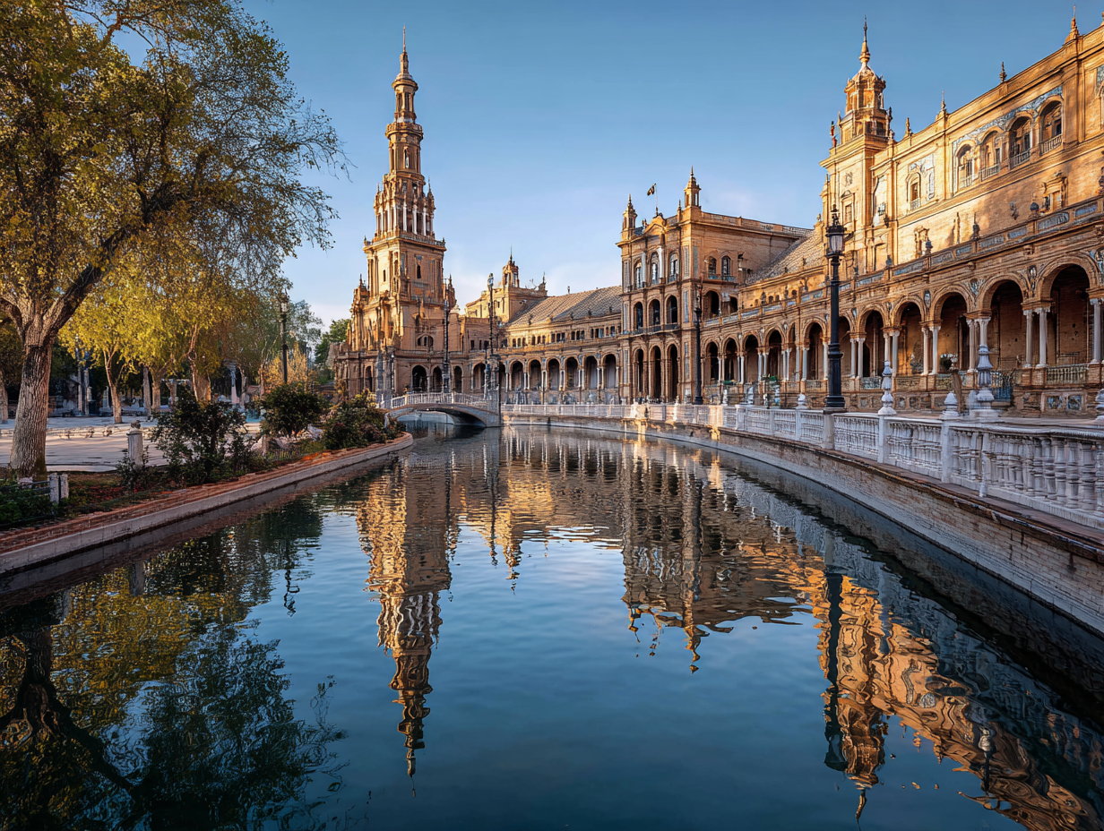
5. Seville, Spain
Seville rewards travelers who avoid the hottest part of the year. Andalucía’s official tourism site describes the region’s climate as warm Mediterranean, with mild winters, dry hot sunny summers, an average year-round temperature of about 18°C, and more than 300 days of sunshine per year. Cooler months allow longer walks around the cathedral area, Santa Cruz, Triana, María Luisa Park, and Plaza de España.
A lower-demand Seville day can start around the cathedral and Giralda area, continue through Santa Cruz, pause for lunch, and move toward Plaza de España or María Luisa Park later in the day. Triana can take another block with ceramics, tapas, riverside walks, and a different neighborhood route across the Guadalquivir.
Summer heat can force visitors to plan around shade, siesta hours, hydration, and shorter outdoor sections. Cooler months give travelers more usable hours for walking, photography, patios, markets, churches, and tapas without building the whole day around midday avoidance.
Major holidays, fairs, Holy Week, and local events can change prices and crowd levels even outside summer. Travelers should check the calendar before booking a supposedly quiet Seville trip, especially around spring celebrations and long weekends.